 Ten
Maplets illustrating the Discovery of South America, 1500-1517
Ten
Maplets illustrating the Discovery of South America, 1500-1517
Back to Table of Contents
FROM Columbus we turn to Magellan.(1) Antonio Pigafetta,(2) the companion of Magellan, and historian of the first voyage round the world, having told us that it was thought formerly that the broad estuary to the south of the Cape of St. Maria afforded access to the South Sea, takes us to a strait discovered on the day of the Eleven Thousand Virgins in 52° S., and says: "Had it not been for the captain-general we could not have found the strait, for we all thought and said that it was closed on all sides. But the captain-general, who knew where to sail to find a well-hidden strait, which he saw depicted on a map in the treasury of the King of Portugal, which was made by that excellent man, Martin de Boemia, sent two ships, the `Santo Antonio' and the `Conception' to discover what was inside the cape of the bay. We, with the other two ships, stayed inside the Bay to await them."
It seems, however, that Magellan's trust in the said map was not absolute, for a little further on Pigafetta tells us that "had we not discovered that strait the captain-general had determined to go as far as 75 degrees towards the Antarctic Pole."
Frey Bartolomé de las Casas,(3) the famous "Protector of the Indians," throws further light upon the plans of Magellan. He was actually present in January, 1518, at Valladolid, when Magellan pointed out to the Lord Chancellor of Castile, J. R. de Fonseca, the Bishop of Burgos, the route which he proposed to follow in making his passage to the Moluccas. He did this by means of a neatly painted globe, upon which the supposed strait had been omitted, so that he might not be robbed of his secret! I cannot believe in so absurd a device. The very existence of a blank upon the globe would have directed attention to the situation of the sought-for strait. It is far more likely that only those coast-lines were shown upon the globe which had been actually discovered up to 1518, and that all hypothetical features had been omitted. This, at all events, would have been in accordance with the prevailing practice in the case of marine charts. Sebastian Alvarez, the factor of the King of Portugal at Seville, confirms this view. He, too, saw the globe, in July, 1512, and says that it was the work of Pedro Reinel(4) and his son, Ferdinand; and that between Cabo Frio and the Moluccas no land was laid down.(5) I have no doubt that instead of Cabo Frio we ought to read Cabo de S. Maria, in which case the globe would have agreed with a Portuguese chart of that period, upon which the Cabo de S. Maria (to the north of the Rio de Solis) in 35° S. is shown(6) as the furthest point known on the East coast of South America, as also with a Memorandum presented by Magellan to King Ferdinand in September, 1519.(7)
But to return to Frey Bartolomé. Having referred to the globe, he goes on to say that Magellan in the course of conversation stated that he would first go and seek the Cabo de S. Maria, near the mouth of the Rio de Solis; that then he would examine the coast to the southward, and, failing to discover a strait communicating with the South Sea (discovered only recently by Vasco Nuñez de Balboa), he would follow the usual course of the Portuguese in their voyages to the East, round the Cape of Good Hope.(8) Not a word is said about Behaim and his chart. A few pages further, however, Las Casas states, on the authority of Pigafetta, that Magellan felt sure of discovering a strait, "having seen it upon a chart in the treasury of the King of Portugal made by Martin de Bohemia, a great pilot and cosmographer.
Oviedo(9) (Historia, liv. XX., c. 1) knows about the reported existence of Behaim's chart, admits that it may have suggested the existence of a strait, but maintains that its discovery was due rather to the capacity of Magellan than to the science of the "Bohemian."
Francisco Lopez de Gomara in his `Historia general de las Indias' (Zaragoza, 1552, c. 91) knows all about Behaim and his "carta de marear," but adds that "as far as he heard that chart showed no strait whatever, unless the Rio de la Plata or some other great river on that coast was taken for such."
Antonio de Herrera,(10) who had access to the archives of Philip III., may have consulted there the original journal of Pigafetta, which had been presented to Charles V., and other documents, now lost to us, but what he tells us in his `Historia general' (Dec. II., liv. II., cc. 19-21) about Behaim, whom he describes as a native of the island of Fayal and a cosmographer of great authority (de gran opinion), and the "hidden" strait, seems to have been borrowed from Las Casas, who was himself dependent upon Pigafetta.
It is significant that João de Barros, the famous Portuguese historian, in the account of the voyage of his countryman Magellan (`Da Asia,' Dec. III., liv. 5, p. 8), whom the "devil had instigated" to desert his own King "for him of Castile," makes no reference whatever to the chart supposed to have existed in the King's treasury. It is evident that he knew nothing about such a chart, or he would surely have referred to it, if only to minimize Magellan's merit in discovering the sought-for strait leading to the South Sea. Gaspar Correa,(11) in his `Lendas de India,' is equally silent.
Indeed, the existence of Behaim's chart seems to be vouched for by Pigafetta alone, and considering the friendly personal relations which existed between him and Magellan, his testimony is undoubtedly of considerable weight. It has been unhesitatingly accepted by many subsequent writers, and among others by William Postel,(12) a learned Frenchman, who speaks of the strait of Martin Bohemus, which separates the new world or Atlantis from the unknown southern continent or Chaesdia, but is named after Magellan because that navigator passed through it on his route to the Moluccas. He evidently looked upon Behaim as the hypothetical if not actual discoverer of this strait. Urbain Chauveton (Calvetonus), in the notes which he added to a Latin translation of Girolamo Benzoni's `Historia del Mondo novo' (Venice, 1565, lib. III., c. 14), which was published at Geneva in 1578, confines himself to the statements made by Pigafetta, and as this work, up to 1650, appeared in at least ten editions, including translations into French, German, Dutch and English, the statement about Behaim's map gained wide currency, and was accepted by quite a host of compilers.
A sketch of the progress of discovery and exploration along the east coast of South America may help us towards a correct opinion as to the likelihood of Behaim having ever designed a chart resembling that with which he is credited by Pigafetta.
Christopher Columbus was the first to sight the mainland of South America, immediately to the south of the island of Trinidad. This happened on August 1, 1498. In the year after, in 1499, on May 18, Alonzo de Hojeda (with whom were Juan de la Cosa, the famous pilot, and Amerigo Vespucci) fell in with the coast further to the east, off Surinam, and followed in the wake of Columbus. In the following year, 1500, on the 20th of January, Vicente Yañez Pinzon, sighted the coast in lat. 8° 20' S. at a low point of land, which he called Cabo de S. Maria de la Consolacion.(13) He then turned to the north and west, discovered the mighty floods of the Marañon, and, like his predecessor, sailed through the Dragon's mouth into the Caribbean Sea. Diego de Lepe, who had left Palos about a month after Pinzon, fell in with the same cape, which he named Rostro hermoso - "the beautiful bill" - and seems to have explored the coast for some distance to the south, before he proceeded to his destination.
Ten
Maplets illustrating the Discovery of South America, 1500-1517
Pedro Alvarez Cabral was the first Portuguese who touched the coast of Brazil. Whether he was carried thither by the equatorial current against his will, or sought for it in virtue of the instructions he had received, is still an open question.(14) He sighted the land on April 21, 1500, in lat. 17° S., and as it was Eastertide he named a conspicuous mountain, which was in front of him, Monte Pascual, and the land itself Terra da Vera Cruz-the land of the true cross. A "safe harbour" - porto seguro-about forty miles to the north of his landfall, afforded him shelter from a storm. Having despatched Gaspar de Lemos to Europe with news of his discovery, he started, on May 3, on his disastrous voyage to the Cape of Good Hope and India. In the course of this voyage he perhaps discovered the small island of Trinidade.(15)
So impressed was the King with the discovery of a resting-place for vessels sailing round the Cape that he almost immediately, on May 13, 1501, despatched an expedition from Lisbon to follow up the discovery made by Cabral. The name of the commander of this expedition is not known, but there is no doubt that Vespucci was a member of it. The expedition fell in with the land in 5° S. at Cabo de S. Roque, after which it followed the coast, certainly as far south as the Rio de Cananea,(16) in 25° S. On February 13 the vessels departed from the land, and having sailed in a south-easterly direction for 500 leagues, to 52° S., they discovered, on April 2, a barren island, along which they coasted for twenty leagues, after which they turned northward towards home.(17)
The Fleet of Affonso de Albuquerque, which left Lisbon on April 16, 1503, seems to have followed the coast of Brazil as far as an Ilha de Santo Amaro which, according to Duarte Pacheco is 3½ degrees to the north of Cabo Frio, which he places in 25°, its true latitude being only 23°. An island of that name off the harbour of Santos, in lat. 24° S., finds a place upon our modern maps, but it is very doubtful whether it is the island referred to by Pacheco.
The last expedition to be noticed had for its avowed object the search for a passage to the spice-lands of the Moluccas by doubling the southern extremity of the "New World." This expedition left Lisbon in June 1503. Gonzalo Coelho seems to have been in command; Vespucci sailed in one of its vessels and, on his own showing, played a leading part. The results were disappointing, for the highest latitude reached was 18° S.
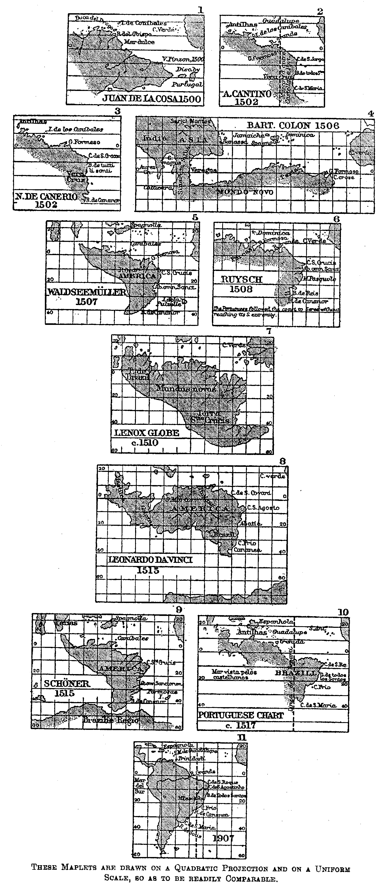
This summary of explorations carried on up to Behaim's death, in 1507, shows us that the Rio de Cananea in lat. 25° 5' S., was the furthest point reached. The charts of the period bear this out,(18) for upon none of them do we find a place name to the south of this river, occasionally corrupted into a Rio de Cananor, and placed as far south as 29° and even 40°. Nor had there been discovered any estuary, or bay, promising to lead into an Eastern Ocean. No "terra australis" or Antarctis is referred to, or shown upon any map. Under these circumstances we are justified in believing that the chart referred to by Pigafetta as showing a "strait" cannot have been the work of Martin Behaim, who died in 1507.(19) At the same time there existed a belief that the southern extremity of the "Land of the True Cross" might be doubled, just in the same way as Africa had been doubled. Waldseemüller's Globe and Map published in the very year of Behaim's death prove this most conclusively.
This "Caput finis Terrae" of the charts was the goal of the expedition under Vicente Yanez Pinzon and Juan Diaz de Solis which left San Lucar in June, 1508. But disputes between the leaders destroyed its chances of success, and it came back in October, 1509, having advanced no further than a Cape of St. Mary(20) to the north of the estuary of La Plata. The estuary between that cape and the Cabo de S. Antonio has a breadth of 120 sea-miles, and even much further within it cannot be seen across. It seems indeed that Diaz de Solis failed to recognise that he had reached the estuary of one of the largest rivers of the world. In this respect a private expedition fitted out by Don Nuño Manuel, the Controller of the Royal Household (Almotacel mór) and Christóbal de Haro, a merchant prince of Antwerp, at that time established at Lisbon, was more successful. One of the pilots whose vessel arrived on October 12, 1514 (21) at Madeira, on the homeward voyage, gave an account of their discoveries to an agent of the famous Welsers of Augsburg who was stationed there. This account was forthwith printed in Germany as a `Newe Zeytung auss Presilly (Brazil) Landt.' We thus learn that the two vessels of the expedition doubled a cape in lat. 40°, or one degree beyond the latitude of the Cape of Good Hope (i.e., 35° S.), and sailed up a "gulf" for sixty leagues when a violent storm (pampero) swept them back into the open sea. The pilot expressed a belief that this "gulf" or strait would enable a ship to sail to "Malaqua," which he thought was distant only 600 leagues,(22) and proposed to make this voyage shortly himself. Who was this "fast friend" of the writer of the `Newe Zeytung,' whom he refers to as "the most famous of the King of Portugal's pilots?" I believe it was João de Lisboa. Gaspar Correa (`Lendas da India,' t. II., p. 528) credits him with having discovered the Cabo de S. Maria, on the northern shore of the estuary of the La Plata; Magellan's pilots are stated(23) to have recognised this cape from a description given by him, and his name is attached, on Diego Ribero's chart (1529), to a cape a little further to the north.
Martin Fernandez d'Enciso, whose `Suma de Geographia' was printed at Seville in 1519, knew that a river twenty leagues broad entered the sea to the south of that cape, and that the country beyond it was inhabited by man-eaters.
In the meantime news had been received of the discovery of a great "Southern Ocean" on September 25, 1513, by Vasco Nuñez de Balboa,(24) and Juan Dias de Solis was despatched for a second time with instructions to seek for a strait or to sail round the southern extremity of Brazil, so that he might join hands with the Spanish forces already on the west coast of the New Continent. He started in October, 1515, explored the estuary of the La Plata, and sailed up the Parana, where he lost his life in a skirmish with natives; upon which his faint-hearted companions returned to Europe.
It will thus be seen that when Magellan submitted his scheme to the authorities in Spain, the west coast of South America was known only as far as the estuary of a huge river, then known as Rio de Solis, and subsequently as Rio de la Plata. Magellan's friend Christóbal de Haro, who had left Lisbon for Seville on account of a denial of justice on the part of King Manuel, and who contributed 4,000 ducats towards the expenses of this expedition, naturally communicated to him the results of his own Brazilian venture of 1514. It was permissible at that time, notwithstanding the second voyage of Diaz de Solis, to believe that the estuary discovered might eventually turn out to be connected with a strait leading to the Mar del Sur, and it is almost certain that this hypothetical strait was shown on charts which Magellan was able to consult. At all events, the existence of such a strait was believed in by a German mathematician, Johann Schöner, who, depending solely upon the scant and misunderstood information of the `Newe Zeytung,' delineates it upon a globe, the gores for which were printed at Nuremberg in 1515.(25) Schöner's name is not engraved upon this globe, and Magellan, who only left Portugal in 1516, may have seen it there, and ascribed it to Behaim. There may even have existed a map in the King's treasury showing such a "hypothetical" strait. Behaim, however, cannot have been the author, for when the news of the discovery of the La Plata first reached Europe he was already dead.(26)
(1) F. F. H. Guillemard, `Life of Magellan,' London, 1890.. back
(2) A. Pigafetta was born about 1480, came to Spain in 1519, and returned to Italy in 1523, where he died about 1534. The MS. of his `Primo Viaggio,' now in the Bibl. Ambrosiana at Milan, was published by Andrea da Mosto in t. V. of the `Raccolta di doc. e studi publicati delle R. Commissione Columbino.' We quote the translation by J. A. Robertson, published at Cleveland, Ohio, in 1906. back
(3) Bartolomé de las Casas was born at Sevilla in 1474, accompanied Columbus on his first voyage, 1492-3, was consecrated a priest in S. Domingos in 1510, paid several visits to Spain to plead for a more humane treatment of the natives, and finally retired to Europe in 1547. He died, 1566, at Madrid. His famous `Historia da las Indias' was begun in 1527, completed in 1547, but only published in 1575-6. (See Harrisse, `Christopher Columbus,' I., p. 122). back
(4) A Portuguese "mestre de cartas," who entered the service of Spain, but returned to Portugal, and was granted a pension by John III. He was still alive in 1542 (Sousa Viterbo, `Trabal. naut. dos Port.,' I., p. 341). back
(5) Navarrete, `Coleccion,' IV., doc. No. 15. back
(6) See p. 36, Maplet No. 10. back
(7) Navarrete, `Coleccion,' IV., doc. No. 19. The object of this Memorandum was to prove that the Moluccas, according to the treaty of Tordesillas, lay within the Spanish sphere. Starting from S. Antão, the outermost of the Cape Verde Islands, Magellan computes the 370 leagues of the treaty to be equivalent to 22° of longitude. As a league was equal to 7,500 varas, or 6,269 metres, a meridian distance of 370 leagues in lat. 17° actually amounts to 21*8 degrees, a very near approach to the truth. The Moluccas were supposed by him to lie only 176° to the west of this "linea de repartição," and to be thus within the Spanish sphere, their true distance being 187°, which placed them within that of the Portuguese. back
(8) `Historia de las Indias,' liv. III., c. 100, vol. IV., Madrid, 1876, p. 376. back
(9) Gonçalo Fernandez Oviedo y Valdes was born at Madrid in 1478, spent 1513-47 in Haiti, and was appointed Royal Historiographer on his return to Europe. He is the author of `La Historia general y natural de las Indias Occidentales,' Seville, 1535-55, a new edition of which was published at Madrid, 1851-55. He died 1557. back
(10) See p. 14, note. back
(11) Gaspar Correa went out to India about 1512 and died there after 1561. His great work remained in MS. until 1858-61, when it was published by the Academy of Sciences at Lisbon. back
(12) In his `Cosmographiae disciplinae Compendium,' Basel, 1561, c. 2; `De Universitate liber,' Paris, 1563. Guillelmus Postellus was born in 1510 at Barenton, in Normandy, and died in 1581. He was a distinguished Oriental scholar, able to read Arab geographers, was expelled from the Society of Jesus, and persecuted by the Inquisition. back
(13) Pinzon (Navarrete, III., doc. No. 69), in the evidence given in 1513, distinctly identifies the Cabo de Consolacion discovered by him with the Cabo de S. Augustin, but an examination of the charts of the period would justify us to look upon the capes consecutively known as Cabo de S. Maria de la Consolation, Rostro hermoso, Cabo de S. Cruz and S. Jorge as being identical with Cabo de S. Roque of the Portuguese in lat. 5° 28' S. back
(14) J. Norberto de Sousa e Silva (`Revista trimensal do inst. hist. do Brazil,' XV., 1852, p. 125) and Capt. A. A. Baldaque da Silva (`Centenario do Descobrimento da America,' Lisbon, 1892) argue in favour of design. back
(15) This would have happened during the first half of May, 1500, in which year Ascension Day fell on May 28 and Trinity Sunday on June 14. There is no doubt, however, that the small island now known as Trinidad, was "found" on May 18, 1502, by Estevão da Gama. The reports of Thomé Lopes (Ramusio, I.) and Mateo of Bergamo (Hümmerich, `Vasco da Gama,' Munich, 1898, p. 193), who both were in this fleet, leave no doubt on this point. The island was once more "found" by Affonso de Albuquerque, in 1503. Duarte Pacheco Pereira, who commanded the "Conceição" in that voyage, calls the island S. Ascenção, and correctly gives its approximate latitude (`Esmeraldo de Situ Orbis,' Lisbon, 1892, p. 16; and also the letter of Giovanni of Empoli published by Ramusio). The island appears for the first time in Dr. Hamy's map, about 1502, but without a name. On a Portuguese chart (see No. 10 of our Maplets, p. 36), three islands are shown, viz., Ascension, Trinidade and Martin Vaz. Ascension and Trinidade evidently refer to the same island, while Martin Vaz, a rocky islet further east, is named after its discoverer, Martin Vaz Pacheco, who went with Pedro de Mascarenhas to India in 1511. Diego Ribero, 1529, has an "Ya de S. M. de agosto," which simply means "Island of the Ascension of St. Mary," which is celebrated on August 15. back
(16) La Cananea is a festival celebrated on the first Thursday in Lent; in 1502, on February 10. back
(17) Valentin Ferdinand (`Abhdlgn. d. bayr. Ak. d. Wiss.,' 3 Cl., t. VIII., 1860, p. 787), in a notarial Act signed on August 4, 1504, refers to this expedition as having sailed to 53° S. Varnhagen, `Amerigo Vespucci' (Lima, 1865, p. 110), suggests that Vespucci reached Southern Georgia in lat. 54°. Perhaps it was the island of Tristão da Cunha, in lat. 37° S., whither he was carried by winds and currents. M. F. d'Enciso, `Suma de Geografia' (Seville, 1519) places a "tierra Austral" 600 leagues to the S.E. ¼ S. of Cabo de S. Agostinho, and 450 leagues from the Cape of Good Hope, in 42° S. This seems to represent the land found by Tristão da Cunha in 1506, but possibly discovered by an earlier expedition. back
(18) See p. 36, Maplets 1-5. back
(19) "It is more than doubtful whether the map seen by Magelhães was actually the work of M. Bebaim" (Dr. Wieser, `Magalhães-Strasse,' 1881, p. 51). The learned Harrisse, on the other hand, believed that "Behaim doubtless traced hypothetically the celebrated strait which Magellan was destined to discover thirty years after" (`Discovery of North America,' Paris, 1892, p. 438). back
(20) This cape,judging from the old charts, is identical, not with the modern Cabo de S. Maria, but with the Cabo de Ballena near Maldonado in 35° S. back
(21) The date was discovered by Dr. K. Häbler in the original MS. still preserved in the archives of the Fugger family (`Zeitschrift für Erdkunde,' Berlin, 1895, p. 352). This discovery disposes of many pages of conjecture regarding the date of the expedition. back
(22) Surely the pilot knew better! The meridian distance between the mouth of the La Plata and Malacca was certainly known to exceed 160°, for it was well known that Malacca, first reached by Lopez de Sequeira, lay within the Portuguese half of the world, or more than 158° to the West of the "Line of Division" as laid down by the Treaty of Tordesillas. Magellan in his `Memorial of September, 1519,' estimates the meridian distance between the Cabo de S. Maria and Malacca at 177½°. The actual difference between the Line of Division and the Moluccas is 186°. These coveted islands were thus 6° within the Portuguese half. back
(23) Herrera, Doc. II., lib. IX., c. 10; Varnhagen, `Historia General de Brazil,' 1854, I., p. 30. back
(24) Bernhard Varenius (b. at Hitzaker, 1622, died 1650, at Amsterdam, shortly before the publication of his famous `Geographia Generalis,' of which Isaac Newton, in 1672, published a revised edition-see Dr. Breusing, in Petermann's Mitth., 1880, p. 136), credits this Balbao with the discovery of Magellan's Strait (`Geogr. gen.,' cc. 12 and 14). back
(25) See Maplet No. 9. back
(26) Antonio Galvão, `The Discoveries of the World' (London, 1862, p. 66), tells us that D. Pedro, in 1428, brought a chart of the world from Venice upon which the Strait of Magellan was called "The Dragon's Tail" (Cola de Dragon) and the Cape of Good Hope "Frunteira de Africa." See A. Ribeiro dos Santos, "Memoria sobre dois antigos Mappas," `Memorias de Litterature Portugueza,' VIII., 1812. This mysterious map has never been discovered and never will be. back
Back to Table of Contents
Last modified: Fri Feb 6 01:18:51 CET 2004